Sunday, November 29, 2009

Roads in the south

I've been in Birmingham, my home town, this Thanksgiving. And I've been looking at the town of my youth through a fresh set of eyes, through a new lens. My impression of Birmingham may now be forever skewed, partially because of my experiences from bike commuting in Denver for a over a year, but more so because of having read the Dangerous by Design report, and because of my ensuing obsession with complete streets and safe infrastructure.

Birmingham streets suck. It's obvious and it's tragic.

As I drive though the heart of downtown and as I drive through the surrounding suburbs, I can't help but feel all kinds of respect and admiration for Elisa, Anna, and all the other souls who choose to brave the roads and bike in the south.

I don't know what it is about rural areas that spell out danger for pedestrians, and the report focuses on metro areas with populations of over one million, so I lack data on smaller rural areas. But I would suspect that small rural towns aren't much safer than large southern cities.

That is, I don't think it unreasonable for Zoe's mom insist she wear construction gear while out for a jog.


No matter where you go, you're likely to hear an assertion following the "People in x drive y" formula. And sometimes there's some truth to these assertions. For example, people in Denver drive through red lights. They just do. I find myself doing it, too. The traffic signals have odd timing cycles.

And people in Birmingham drive fast, through neighborhoods and down side streets, amongst pedestrians and joggers and people walking their dogs who don't have sidewalks or other mobility options.

Edit: It was just brought to my attention on BikeSkirt that Alabama ranked dead last, 50 out of 50, on the League's list of Bicycle Friendly States this year.

It's depressing and it's discouraging, but I find hope in the fact that several of the most dangerous metro areas are now also leading the pack in spending on walking and biking. It suggests to me that they have realized that something is wrong and the cities are now taking steps toward fixing the problem.

And I'm encouraged by advocacy groups like Birmingham's Bicci Coop, and these guys, who are organizing a car free week in Jackson, Mississippi, a town too small to land on the list of 52 large metro areas, but which has a pedestrian danger index higher than the fifth most dangerous area.

So. Good luck to them and to everybody else out there drawing attention to inadequate and dangerous infrastructure.

I hope you soon get to enjoy the safe roads you deserve and that you don't get hit by a car before then.

Monday, November 23, 2009

Can pretty people literally stop traffic?

Found a research paper, Designing Roads that Guide Drivers to Choose Safer Speeds (pdf), that's interesting to skim over. The authors are able quantify how much things like sidewalks/curbs, on-street parking, and building setback affect how fast drivers choose to drive.

For example, given two streets with speed limits of 35 mph, drivers on the one with a sidewalk average 34.7 mph. Drivers on the road without the sidewalk averages 42 mph.

One of the most interesting parts of this report is the effect of beauty on the speed of traffic. A line pulled from the report and highlighted on the Tom Vanderbilt Traffic blog
The aesthetics or “beauty” of a road environment has also been investigated in relation to traffic safety. Drottenborg (1999) studied the impact of speed on streets that appear as “beautiful” due to the blossoming of cherry trees along the streets in Lund during springtime, and similar streets that lack such beautification. She found that the free-flow mean speed decreased by about 5 percent and the number of vehicles traveling at high speeds between 50-60 km/h decreased by about 12 percent during the cherry blossom period.

That's pretty awesome.

And I know it to be true. I definitely slow to an amble down streets like Montview when the leaves are starting to change.

Of course, there is an associated increase in the appreciation of your surroundings as you slow down. It allows you to stop and smell the proverbial roses. Or coffee. Or bacon. Or whatever it is you like to smell.

And I have to be careful not so succumb to modal bias here. You can see and appreciate more on a bicycle than you can zooming along in your car. But I've definitely seen and noticed things while strolling on foot that I missed while zooming along on my bike.

Thursday, November 19, 2009

D2: From Lakeside Amusement to Wall Mart

Route summary!


D2. The northernmost E/W route on the grid. It stretches from the Denver/Jefferson county at 43rd and Sheridan, by Lakeside Amusement Park and Berkeley Lake, across town to Wall Mart, just this side of Stapleton. And between the two endpoints is a nice little ride!


  • 0.00 miles - West 43rd Avenue and Sheridan Boulevard. This initial stretch of road is pleasant because you start out right on Berkeley Park. I loved going to this park when I lived near here. It has a rec center with a pool, a fenced in dog park, a public library, a big lake with fishing and a walking trail around it. It was tempting to stop the ride before it even began and loiter about, enjoying the morning here.

  • 0.07 miles - Double sharrows!

  • 0.52 miles - DOUBLE EFFING SHARROWS. (At Tennyson St.) There are three generations of sharrows painted on this street. The most recent ones look bold and bright. The next oldest are clearly visible, and the oldest ones are very faded. But you can see nearly all of them clearly enough. There's one every couple of feet! It's impossible for a motorist on this street not to know that there may be bicycles about.


  • 1.14 miles - Rocky Mountain Lake Park. Another park. With another lake. But this one has a big damn frog.

    And how does this rinky-dink little park win the thousand dollar name of "Rocky Mountain Park?" Is it the big damn frog? Must be.

  • 2.60 miles - Turn right onto Navajo Street. The turn is labeled. If you're paying attention, you can't miss it.

  • 2.92 miles - Turn left at West 43rd Avenue. This turn is not labeled. If you don't know to turn here, you'll miss out on the best part of ride, coming up ahead.

  • 3.24 miles - 43rd Avenue dead ends at Inca Street. At the 43rd Ave Foot Bridge!

    I wasn't positive this thing existed. I decided to do this ride in the first place because somebody arrived at this website by searching for "denver d-2 bicycle 43rd bridge." I felt bad for whoever that was because I, until now, I didn't have a lick of information about it.

    So when you turn on to it, 43rd dead ends after only a few blocks at Inca Street. Beyond Inca are the train tracks. Before the tracks is a several stories tall foot bridge. I didn't think it was open at first because of the abandoned fire tower look it has, but when I went in for a closer look, I discovered that it's a solid, concrete over pass. There's a small stairwell in the middle that you have to carry your bike up (PORTAGE!) and then you have to carry it back down the other side again, obviously. And then there's a small patch of dirt between you and where 43rd continues.

    Portaged my bike and got some mud on my tires. Awesome.


  • 3.45 miles - Left on Fox Street.

  • 3.53 miles - Turn right onto West 44th Avenue, which will carry you right over I-25, and then curve north to parallel the freeway.

  • 3.99 miles - Turn right onto East 45th Avenue. And welcome to Globeville! This is a neat little neighborhood. Globeville proper spreads out farther than this, but this is a cute little 3x8 blocks neighborhood confined by I-25 the to west, I-70 to the north, and the Platte River to the south and east. Watch out for the White Owl on your left. Apparently a groovy little dive bar. I'll have to go back for a few brewskies some time.


  • 4.46 miles - Across Washington Street is BikeDonalds, which sits right on the South Platte trail, has ample bike parking and bicycle themed art on the walls inside. Either stop for a milkshake, or continue through the parking lot, onto the trail, and north one exit.

  • 4.72 miles - Go under E 47th Ave (it's labeled), keep going for a heartbeat and then turn around and proceed up the ramp. Turn left onto 47th and continue towards the Colosseum/National Western Complex. 47th Street will go underneath I-70 and then dead-end at a stop sign. Turn left. Hard left. Onto Humboldt.

  • 5.32 miles - Turn right onto East 47th Avenue.

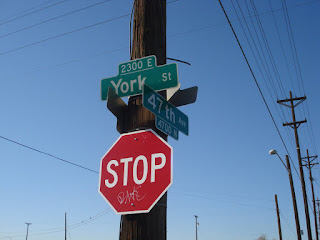
  • 5.92 miles - Here's a funky little place where 47th starts to curve northwards, and then crosses York and you have to turn hard right, almost doubling back the way you came, and then continue across to remain on 47th. It's not tricky. It'll make sense when you see it. It's not a big deal.


  • 6.24 miles - Right onto Clayton

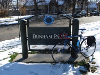
  • 6.54 miles - Past Dunham Park and then left onto 44th.


  • 6.77 miles - Right onto Steele. The first block or two of this stretch of Steele is pretty unwelcoming, but it gets friendlier.

    This is the beginning of an annoying two mile detour that is necessary to get around the damn puppy chow plant.

  • 6.90 miles - Between 43rd and 42nd, there are some train tracks that proceed east from here to Smith Road, which is where we ultimately want to go. I didn't investigate at the time, but if there is some cleared brush along the tracks that might support a mountain, or otherwise-off-roadable, bike then this could cut almost two miles off the route, as well as offer a brief, natural, rails-to-trails style respite from the otherwise very urban route.

    Warrants further attention.

  • 7.59 miles - Right onto E 35th Ave/Bruce Randolph. Down shift before turning. There's a steep little climb for one block. Continue past the City of Nairobi Park.

  • 7.97 miles - Left onto Jackson.

  • 8.72 miles - Jackson veers right and becomes Smith Road. Continue along Smith. Smith runs right next to the rail road tracks. I had the misfortune of riding down Smith once while a train was passing. The noise from the train was so loud that I couldn't hear anything, so I never knew a car was behind me until I could see it at my side as it passed me. Scary!

    Watch out for where the tracks cross the road here. They'll rattle your bones a little.

  • 10.71 miles - Just west of Quebec is the "Last Bus Stop In Town." It's a filthy little bus stop, the closest one to the mega big-box strip mall across the street. If you pass by here at the right time of day, you'll see six foot tall piles of Wall Mart and Home Depot shopping carts. It's the only solution for people who are dependent on the bus for transportation and who also need to do low-price/high-volume shopping.

    There's definitely an opportunity here for something. Be it some kind of a cart return service, or a shuttle service to and from the bus stop. Or maybe just a nicer bus stop. One that's not a bench surrounded by mud and litter. A canopy, some pavement, a trash can, and a cart return would do wonders, really.

  • 12.00 miles - Wall Mart. Effectively the end of the route.


  • 12.14 miles - End. The actual end of the route. Between Wall Mart and here, there are lots of prairie dogs to bark at you.

    The speed with which industrial/residential land turns into natural/feral land makes me realize and appreciate how much we're imposing our modern, urban lives upon the original, kinder and gentler, more natural inhabitants of the area. Those prairie dogs don't know what Wall Mart is, but they don't know what bikes are either.


To wrap up loose ends, I thought I'd return home at this point by jumping on the Sand Creek trail, which appeared to intersect Smith Road here. But I was unable to find it!

I think. Maybe I found it. But Smith Road was blocked off due to some kind of construction related in no doubt to the expansion of the nearby subdivision. So I veered into, and got lost in, the underbelly of Stapleton. I floundered around for quite a while until I stumbled upon Westerly Creek, which I was able to follow down to Montview and, ultimately, home.

I find it easy to protest Stapleton's cookie-cutter, "little boxes" style of development. But the streets were so nice. Wide, with sidewalks and bike lanes. And walking/biking trails all over the place.

They're doing some things right.

Sunday, November 15, 2009

bicycle parking


Yehuda taking advantage of available street parking. The first things I thought of when I saw were—
  1. That's totally legal. If you feed the meter, the space is apparently yours, whether or not you choose to fill it with a car.
  2. That's the concept behind Parking Day, an event that Denver participates in, but during which I have had to work for the last two years and so have never seen it in execution.


I'm afraid I discovered in myself a double standard the other day. While I support—and find humor in—Yehuda claiming equal access here, I caught myself cursing the owner of the Honda Ruckus that is still parked perpendicular to the curb alongside which I was trying to find parking. Its spacing from the corner made it such that it occupied an entire car's length. It could have been parked neatly between two cars, or on the sidewalk where every other 50cc in the neighborhood roosts.

I guess I'll cut him some slack.


It would be neat as hell to see a couple parallel parking spaces allocated for bike parking. That bike cage adequately addresses security in addition to the mere availability of space. I almost can't imagine a world in which you don't need to worry about securing your bicycle, but such places purportedly exist. For example, there are apparently no bike thieves in Copenhagen.

Friday, November 13, 2009

Pedestrian safety in Denver and elsewhere

Denver's rankings in T4A's "Dangerous by Design" report


Transportation for America released its Dangerous By Design report this week. The report assesses the danger of walking in major US metropolitan areas, and ranks the cities according to their Pedestrian Danger Index.

Fifty two metro areas were assessed. Denver ranked 23, with a PDI of 75.6, which makes it more dangerous than 55% of other areas. We're off the average of 77.4 by 1.8 points.

It is interesting to note that the ten most dangerous metro areas are all in the south, with the top four all being in Florida (Orlando/Kissimmee, Tampa/St. Petersburg/Clearwater, Miami/Fort Lauderdale/Pompano Beach, and Jackson). Having spent nearly all of my formative years in the south, I have to say this doesn't surprise me. It has been my experience that roads often narrow and lack sidewalks, and traffic flows through much too fast through residential and commercial areas alike.

Another table in the report shows the absolute number of pedestrian deaths, unadjusted—as the PDI is—for the number of people walking to work. Denver is tied for ninth most dangerous on this list with San Diego.

So absolute number of pedestrians killed by traffic in Denver is well above the norm, but because we have a proportionately large number of people walking to work, our PDI index is close to average.

New York City occupies a unique place on this list. It has among the highest number of actual deaths, and one of the lowest PDIs. Because they have by far the largest number of pedestrian commuters: 6% of all commuters, compared to an average among the other large metro area of 2.2%

Another figure reported is the average federal funds spent each year, per person, on biking/walking projects. Denver allocates $0.65 of its transportation budget, which gives it a ranking of 42/52 on this list. Bottom 10.

Interestingly, Tampa and Jacksonville, the 2nd and 4th most dangerous cities, are near the top of this list, shelling out $1.86 and $2.25 respectively. This is encouraging because it leads one to assume that the cities have recognized and are addressing the dangers detailed in this report.

Here are the figures for the other parts of Colorado.

Safety Rank within stateMetro AreaPedestrian Danger IndexTotal Ped. Fatalities (2007-2008)% of Traffic Deaths that were pedestriansAvg Yr Fed $ spent per person% workers walking to work2008 Population
1Denver-Aurora75.67920.4%$0.65 2.1%2,506,626
2Grand Junction38.237.0%$1.332.8%143,171
3Pueblo34.124.1%$1.081.9%156,737
4Greeley21.433.3%$0.412.9%249,775
5Boulder16.7410.5%$3.554.1%293,161
6Fort Collins-Loveland12.623.9%$1.732.7%292,825
7Colorado Springs6.733.4$0.693.7%617,714


Denver is obviously the most dangerous place to walk. Hopefully that will change as our Living Streets task force begins accomplishing tasks.

LAB's "Bicycle Friendly Communities" with Pedestrian Danger Index


The League of American Bicyclists maintains a list of "Bike Friendly Communities." as part of their Bicycle Friendly America program. Communities are evaluated on "the 5 Es" (Engineering, Education, Encouragement, Enforcement, and Evaluation & Planning) and a 28 page whopper of an application submitted by a representative of the community.

T4A's Pedestrian Danger Index cannot be applied directly to this list because the areas are defined differently. T4A defines "metro areas" such as Denver-Aurora, with a population of over 2 million. LAB "communities" tend to be defined by city boundaries, giving Denver a population just over 550,000.

But anyway, for curiosity's sake here are all cities in the top two tiers (Platinum, and gold) with, where available, the corresponding PDI.

City/CommunityRankPDI
Boulder, ColoradoPlatinum16.7
Davis, CaliforniaPlatinumNot available
Portland, Oregon
(PDI includes data from Vancouver and Beaverton)
Platinum36.4
Corvallis, OregonGold7.9
Eugene, Oregon
(PDI includes data from Springfield)
Gold31.3
Fort Collins, Colorado
(PDI includes data from Loveland)
Gold12.6
Jackson, WyomingGoldNot available
Madison, WisconsinGold7.8
Palo AltoGoldNot available
San Fransisco, California
(PDI includes data from Oakland and Freemont.)
Gold40.9
Seattle, Washington
(PDI includes data from Tacoma and Bellevue.)
Gold31.1
Stanford University, CaliforniaGoldNot available.
Tucson/East Pima, ArizonaGold72.8


Like I said, you can't really apply the PDI directly to this list, but it's interesting nonetheless.

That's all for now. I'm going to keep pouring through this report.

Thursday, November 12, 2009

One year of carfree living

I sold my car exactly one year ago. As of today, I have been car-free for one year.

During the past year, I've ridden in the dark, and during the day. In gorgeous weather, in the rain, and through the snow.

I've put my bike on the bus. I've cursed the bus on snowy days when I needed it and it simply didn't come.

I've fallen down.

I've puzzled over how best to carry stuff to work, and thrilled over new roads and alternate routes.

I've motivated coworkers to occasionally bike to work.

I've had a lot of fun.

And here starts one more year of one less car.

Tuesday, November 10, 2009

Bicycle Diaries


I'm off tomorrow, and I just got a hold of the new David Byrne book.

Score.

Ciclovia

"Ciclovia" is a Latin term referring to an event during which major roads are closed to automobile traffic so that pedestrians and non-motorized vehicles can flourish, thrive, and otherwise assume control of the streets.

I learned the word this morning from an LA Times article via the League of American Bicyclists. Apparently in Los Angeles, local advocacy group cicLAvia is gaining some support from the city council for organizing some ciclovias in downtown LA.

Now, we have our own ciclovias here in Denver, where we have "1st Sundays in the Park" at Cheesman Park five months out of the year, May through September. And that's cool. It's a lot more than other places get.

And our ciclovias being on Sundays, you can further flex your cyclist's rights by venturing two blocks north, down the Teenybopper Mallrat Route and down the 16th Street Mall should you feel like it!

Friday, November 6, 2009

Geohashing

Geohashing is a method for finding an effectively random location nearby and visiting it: a Spontaneous Adventure Generator. Every day, the algorithm generates a new set of coordinates for each 1°×1° latitude/longitude zone (known as a graticule) in the world. The coordinates can be anywhere -- in the forest, in a city, on a mountain, or even in the middle of a lake! Everyone in a given region gets the same set of coordinates relative to their graticule.


"Spontaneous Adventure Generator!" That sums up the appeal of this little game for me! It's the same thing I find appealing in planning out 60+ weekend rides. Trying new trails, plotting new routes. ADVENTURE!

Denver is geographically unfortunate because it is what is called a "split city," meaning that an intersection of graticules, those 1x1 longitude/latitude grids, falls almost directly in the middle of the city, and so we recognize four of them in our area: NE, SE, NW, SW.

Which means that our field of play grows from about 3,381 square miles (69 miles to a degree of latitude by approximately 49 miles to a degree of longitude at 45 degrees form the equator) to four times that at 13,524 square miles.

Which is a friggin lot.

The city and county of Denver is ~155 square miles.

So there's almost a 1/50 chance that it will fall within 10 miles of Denver.

Which all goes to say that in these parts, if a hashsite happens to be a reasonable distance from you, it's a shame not to go after it.

Like I did on Hallowe'en Eve.

Edit:

According to the tool at chemical-ecology.net the four-graticules sized grid is 138.09353334000397 miles by 107.31667373389479 miles long, or 14819.738662209928518 miles square. My original estimate was off by about a thousand miles. I'll now assert confidently, when asked, that our playing field is about 14,819.75 square miles.

Tuesday, November 3, 2009

Folders

LGRAB announces they have a new Jango Flik to test ride and review one day after admitting the allure of a folding bicycle!

They've previously reviewed Dahon folders, so I'm looking forward to a full write-up and comparison.

Monday, November 2, 2009

Don't want to use them, but don't want them to go away

As winter approaches, I begin avoiding bike lanes because they tend to fill up with snow, slush, leaves, and other debris.

But I don't want to contribute to the notion or to any statistics about bike infrastructure not being used.

How to I reconcile these two conflicting desires?

Bike around the world

So the other day, I rode home from the airport.

That accomplishment really captured my imagination.

I fantasize now about biking to the airport, packing up my bike somehow, jetting off to some distant place, unpacking my bike, and then continuing my ride.

Rental cars? Where we're going we don't need rental cars.


There are ways of accomplishing this.

S&S Couplers

One is a product from S and S Machines called Bicycle Torque Couplings (BTC), and which most of the rest of the world call "S&S couplers."

It enables you a trusted bike mechanic to essentially saw your frame in half and install these couplers. After that, you're able to disassemble your bicycle whenever you please in such a way that it fits into regular-sized luggage. That is, you can check it as you would any other bag and not have to pay an over-sized baggage fee.

Some frames, like Surly's Travelers Check, come pre-built using this technology. Other bikesworks offer to retrofit your favorite frame.

The appeal of this technology is obviously having a full-sized, travel-ready bike. Larger riders like myself might be skeptical of the integrity, comfort, and cargo capacity of the other obvious travel solution: a folding bike.

Folding bikes

Which brings us to folding bicycles. Like the Bike Friday variety.

They don't really appeal to me. And they don't really seem marketed as a solution to airline travel the way S&S Couplers are. Rather, they seem marketed to urban commuters who have short distances to travel and who are worried about space on the train for their bikes. Or space in their office cube for their bike.

I know Bike Friday's site has pictures of folks on tour with their foldies, but I'm just not really buying it.

But they do have their place.

And there are some groovy looking ideas on the drawing board.

Other powered

And then just for fun, there are motorized devices like Honda's the U3-X, and Yike Bike.

Being the elitist that I am, I commend them for their small footprint and then dismiss them for not being human powered.

And more importantly, you can't take those things on a tour of the San Diego countryside. They are commuter tools. Not traveling tools.

And in summary

I think the solution for me would be an S&S Coupler ready bike. And as far as those go, Surly's frame is pretty awesome.

I'm going to go pour over the specs and daydream.

Sunday, November 1, 2009

Bikes, burritos, and the Benevolent Bovine


Apparently locally-owned Chipotle is one of the sponsors for professional cycling team Garmin-Slipstream.

My interest in cycling is practical and not competitive, so there's really no reason for me to have known that before last night, when the Lady and I were on Chipotle's site looking for locations participating in Free Burrito Night.

(Free Burrito Night being every Halloween, from 6 PM - 10 PM. Show up dressed as a burrito—i.e., with a piece of tin foil somewhere on your person—and you get a free burrito. It's a family tradition here in the Unclefather household.)

In addition to team info, it includes a nifty little flash game called slipstream ride, wherein you play an easily toppled cyclist who is uprighted after each spill by a flying cow. The Benevolent Bovine.

Who I guess is later, at the end of the race, turned into burrito stuffing, to be enjoyed by the winners. Such a benevolent bovine!

Weird little game.

As far as bicycle related flash games go, I'll be sticking to my cyclomaniacs.

Ride safely! And should you stumble, may the Benevolent Bovine set you upright again!