Tuesday, December 8, 2009

plundered a wallet

826 Valencia's "Goals for the Voyage" so closely mirror the objectives of the Bike Pirates that we have officially adopted them as our own.


"Meet New People" is something you obviously do at events, during group rides, and on the interwebs. To Learn Valuable New Skills such as bicycle repair/maintenance is important and might save your behind out there on the road or trail. And to Plunder is fun! Or at least interesting, as documented from time to time in Flickr's Roadside Finds group.

And it is plundering that I wish to talk about today!

On the way to work last week, I saw a wallet lying near the gutter of the street. It was one of those things that, had I been in a car, I would never ever have seen in the first place, nor would I have been able or inclined to stop, turn around, and go back for it.

But I was on my bike, so I did see it. And I did stop, turn around, and go back for it.

But I was also on my way to work, so after I confirmed that there was nobody nearby who might have dropped a wallet, I continued on my way while planning to investigate the found wallet once I got to my destination. After, that is, stopping on the way for a coffee and a breakfast sandwich. I didn't want to alter my commute plans just because I found a wallet on the ground!

Searching the wallet later, I was able to learn the owner's phone number, which was disconnected, his email address, which produced results on neither MySpace nor Facebook, and his street address, which was on my way home. I also learned all the details concerning the owner's Initial Arrival because his original birth certificate was folded into the billfold!

Left with only street address, I struck out after work with the intention of knocking on doors.

I wouldn't recommend that anybody go knocking on doors by themselves after dark like I did, by the way. I didn't think too much of it until I found myself trying to explain my presence to a wary and skeptical looking older lady who eventually decided I must be harmless, identified herself as the owner's aunt, and accepted the wallet.

I hope she was telling me the truth!

People, bikes lead to adventures.

Boneshaker!

I got my first issue of the Boneshaker Almanac last night!

It's a small little publication, pocket-sized and looking just like the Field Guide it claims to be. It doesn't lack anything because of size, though. The goodness starts just inside the front cover, upper left hand corner, with the publishers information and the copyright information, similar to Dave Eggars' A Heartbreaking Work Of Staggering Genius.

Speaking of the publisher, Wolverine Farms Publishing is based nearby in Fort Collins. Like New Belgium Brewery, which is the first thing I think of when I think of Fort Collins, and that would be simply a coincidental association if it weren't for the New Belgium banner at the top of the Wolverine Farms website. I'm not sure what the connection is there, but I'm not surprised by it. New Belgium is pretty well established in the bike scene, and Wolverine Farms publishes bike almanac. So I guess they would be friends.

The neat thing about the publisher being so nearby is that some of the content is real local news.

Like the picture of Pennyfarthing Guy that appears in the middle of the advice column. I've seen Pennyfarthing Guy pedaling down Cherry Creek, and I saw him at BikeDenver.org's volunteer appreciation party, although I didn't introduce myself.

And like the interview with Brad Evans, editor of Kickstand Magazine and Denver Cruisers Ride architect, wherein he totally called out and heaped scorn upon the skofflaw BIKE NINJAS and their unilluminated ways. Brad Evans, I hereby bestow upon you the title of "Honorary Bike Pirate."

The content wasn't all local though, not by any means. There are blips and blurbs from Texas and beyond, including a bit about biking in Birmingham by Elisa from bikeskirt!

It has the aforementioned advice column, and a book review of David Byrne's Bicycle Diaries. I'm not even finished reading this almanac yet, but I'm obviously tickled thus far.

By which I mean to say, subscriptions are cheap and I endorse it. Go ahead and order a couple copies.

cold cold cold

Bikes and the City made (an ironic) reference to the "cold" 40 degree weather they're having in San Fransisco right now.

Which made me grumble.

We're experiencing a prolonged snap of "cold" 5 degree weather. Which is problematic in that the streets having un-frozen for a couple days now. Cold weather I can handle, but I don't enjoy riding on ice because I don't enjoy falling down.

Consequently, I've been off the bike for two days now and commuting by car feels strange.

Sunday, December 6, 2009

anti-theft spray

This just in! Workcycles sells an Anti-Theft Spray.

umbrellas in the rain

So this post on Bakfiets en Meer touches on the fact that the dutch are likely to bike in the rain. Which is fine and good. I've ridden in the rain, and it can be enjoyable under the right conditions.

What the post doesn't explicitly say, but does depict in the accompanying image, is that a lot of cyclists choose to bike in the rain while holding an umbrella.

Not like this crazy banana-helmet dude.

But more like, you know, one hand on the handlebar and one hand on the umbrella.

Which sounds crazy dangerous, right?

Although you can apparently ride with 1.6 hands on the handles like the Japanese:
In Japan, when it rains it is common to see cyclists holding umbrellas. I watched closely, and it seemed like they hold the handle between their thumb and first finger, while keeping the other three on the brake lever.

Of course, sidewalk riding is also common there, so perhaps Japanese practice is not the safest in the world.
bikeforums.net

All the same, I don't think I could I could do it. I imagine it would be far too distracting and akin to biking while talking on your cell-phone. And cell-phoning while driving is something I wasn't on board with even before reading Traffic.

Wednesday, December 2, 2009

ice bike


Especially my front tire. I was pretty much riding on the rim, and I have no idea how I didn't notice. I must have been focusing too hard on the ice and the traffic.

When I parked my bike, both tires were covered in a thin layer of water/snow, through which the escaping air bubbled and hissed and mini-gurgled. It's a weird noise and when you hear it, it's obvious that it's not good.

When I went to pull out the front tube to patch it, I noticed that it wasn't 100% flat as I had thought. It was more like 75% flat, but seemed to be holding air at that point. I was curious about whether the sealant goop had somehow gooped up and sealed the leak, so I just pumped both the tires up instead of pulling it all apart.

The front one held. So, yippee!

The rear one apparently has a slow leak, but slow enough to let me ride home on it after another pre-departure pump.

I'll have to find and patch that leak tomorrow.

On the way home, about four blocks from work, I wobbled on some ice and fell down. A Schwann's truck that was approaching me slowed, and the driver hollered out the window, "Whoa dude, are you okay?"

"Yeah, thanks!" I answered.

"That ice is hard," he called.

"Yup."

At that point we both continued along our original trajectories.

Sunday, November 29, 2009

Roads in the south

I've been in Birmingham, my home town, this Thanksgiving. And I've been looking at the town of my youth through a fresh set of eyes, through a new lens. My impression of Birmingham may now be forever skewed, partially because of my experiences from bike commuting in Denver for a over a year, but more so because of having read the Dangerous by Design report, and because of my ensuing obsession with complete streets and safe infrastructure.

Birmingham streets suck. It's obvious and it's tragic.

As I drive though the heart of downtown and as I drive through the surrounding suburbs, I can't help but feel all kinds of respect and admiration for Elisa, Anna, and all the other souls who choose to brave the roads and bike in the south.

I don't know what it is about rural areas that spell out danger for pedestrians, and the report focuses on metro areas with populations of over one million, so I lack data on smaller rural areas. But I would suspect that small rural towns aren't much safer than large southern cities.

That is, I don't think it unreasonable for Zoe's mom insist she wear construction gear while out for a jog.


No matter where you go, you're likely to hear an assertion following the "People in x drive y" formula. And sometimes there's some truth to these assertions. For example, people in Denver drive through red lights. They just do. I find myself doing it, too. The traffic signals have odd timing cycles.

And people in Birmingham drive fast, through neighborhoods and down side streets, amongst pedestrians and joggers and people walking their dogs who don't have sidewalks or other mobility options.

Edit: It was just brought to my attention on BikeSkirt that Alabama ranked dead last, 50 out of 50, on the League's list of Bicycle Friendly States this year.

It's depressing and it's discouraging, but I find hope in the fact that several of the most dangerous metro areas are now also leading the pack in spending on walking and biking. It suggests to me that they have realized that something is wrong and the cities are now taking steps toward fixing the problem.

And I'm encouraged by advocacy groups like Birmingham's Bicci Coop, and these guys, who are organizing a car free week in Jackson, Mississippi, a town too small to land on the list of 52 large metro areas, but which has a pedestrian danger index higher than the fifth most dangerous area.

So. Good luck to them and to everybody else out there drawing attention to inadequate and dangerous infrastructure.

I hope you soon get to enjoy the safe roads you deserve and that you don't get hit by a car before then.

Monday, November 23, 2009

Can pretty people literally stop traffic?

Found a research paper, Designing Roads that Guide Drivers to Choose Safer Speeds (pdf), that's interesting to skim over. The authors are able quantify how much things like sidewalks/curbs, on-street parking, and building setback affect how fast drivers choose to drive.

For example, given two streets with speed limits of 35 mph, drivers on the one with a sidewalk average 34.7 mph. Drivers on the road without the sidewalk averages 42 mph.

One of the most interesting parts of this report is the effect of beauty on the speed of traffic. A line pulled from the report and highlighted on the Tom Vanderbilt Traffic blog
The aesthetics or “beauty” of a road environment has also been investigated in relation to traffic safety. Drottenborg (1999) studied the impact of speed on streets that appear as “beautiful” due to the blossoming of cherry trees along the streets in Lund during springtime, and similar streets that lack such beautification. She found that the free-flow mean speed decreased by about 5 percent and the number of vehicles traveling at high speeds between 50-60 km/h decreased by about 12 percent during the cherry blossom period.

That's pretty awesome.

And I know it to be true. I definitely slow to an amble down streets like Montview when the leaves are starting to change.

Of course, there is an associated increase in the appreciation of your surroundings as you slow down. It allows you to stop and smell the proverbial roses. Or coffee. Or bacon. Or whatever it is you like to smell.

And I have to be careful not so succumb to modal bias here. You can see and appreciate more on a bicycle than you can zooming along in your car. But I've definitely seen and noticed things while strolling on foot that I missed while zooming along on my bike.

Thursday, November 19, 2009

D2: From Lakeside Amusement to Wall Mart

Route summary!


D2. The northernmost E/W route on the grid. It stretches from the Denver/Jefferson county at 43rd and Sheridan, by Lakeside Amusement Park and Berkeley Lake, across town to Wall Mart, just this side of Stapleton. And between the two endpoints is a nice little ride!


  • 0.00 miles - West 43rd Avenue and Sheridan Boulevard. This initial stretch of road is pleasant because you start out right on Berkeley Park. I loved going to this park when I lived near here. It has a rec center with a pool, a fenced in dog park, a public library, a big lake with fishing and a walking trail around it. It was tempting to stop the ride before it even began and loiter about, enjoying the morning here.

  • 0.07 miles - Double sharrows!

  • 0.52 miles - DOUBLE EFFING SHARROWS. (At Tennyson St.) There are three generations of sharrows painted on this street. The most recent ones look bold and bright. The next oldest are clearly visible, and the oldest ones are very faded. But you can see nearly all of them clearly enough. There's one every couple of feet! It's impossible for a motorist on this street not to know that there may be bicycles about.


  • 1.14 miles - Rocky Mountain Lake Park. Another park. With another lake. But this one has a big damn frog.

    And how does this rinky-dink little park win the thousand dollar name of "Rocky Mountain Park?" Is it the big damn frog? Must be.

  • 2.60 miles - Turn right onto Navajo Street. The turn is labeled. If you're paying attention, you can't miss it.

  • 2.92 miles - Turn left at West 43rd Avenue. This turn is not labeled. If you don't know to turn here, you'll miss out on the best part of ride, coming up ahead.

  • 3.24 miles - 43rd Avenue dead ends at Inca Street. At the 43rd Ave Foot Bridge!

    I wasn't positive this thing existed. I decided to do this ride in the first place because somebody arrived at this website by searching for "denver d-2 bicycle 43rd bridge." I felt bad for whoever that was because I, until now, I didn't have a lick of information about it.

    So when you turn on to it, 43rd dead ends after only a few blocks at Inca Street. Beyond Inca are the train tracks. Before the tracks is a several stories tall foot bridge. I didn't think it was open at first because of the abandoned fire tower look it has, but when I went in for a closer look, I discovered that it's a solid, concrete over pass. There's a small stairwell in the middle that you have to carry your bike up (PORTAGE!) and then you have to carry it back down the other side again, obviously. And then there's a small patch of dirt between you and where 43rd continues.

    Portaged my bike and got some mud on my tires. Awesome.


  • 3.45 miles - Left on Fox Street.

  • 3.53 miles - Turn right onto West 44th Avenue, which will carry you right over I-25, and then curve north to parallel the freeway.

  • 3.99 miles - Turn right onto East 45th Avenue. And welcome to Globeville! This is a neat little neighborhood. Globeville proper spreads out farther than this, but this is a cute little 3x8 blocks neighborhood confined by I-25 the to west, I-70 to the north, and the Platte River to the south and east. Watch out for the White Owl on your left. Apparently a groovy little dive bar. I'll have to go back for a few brewskies some time.


  • 4.46 miles - Across Washington Street is BikeDonalds, which sits right on the South Platte trail, has ample bike parking and bicycle themed art on the walls inside. Either stop for a milkshake, or continue through the parking lot, onto the trail, and north one exit.

  • 4.72 miles - Go under E 47th Ave (it's labeled), keep going for a heartbeat and then turn around and proceed up the ramp. Turn left onto 47th and continue towards the Colosseum/National Western Complex. 47th Street will go underneath I-70 and then dead-end at a stop sign. Turn left. Hard left. Onto Humboldt.

  • 5.32 miles - Turn right onto East 47th Avenue.

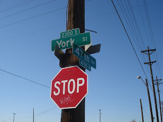
  • 5.92 miles - Here's a funky little place where 47th starts to curve northwards, and then crosses York and you have to turn hard right, almost doubling back the way you came, and then continue across to remain on 47th. It's not tricky. It'll make sense when you see it. It's not a big deal.


  • 6.24 miles - Right onto Clayton

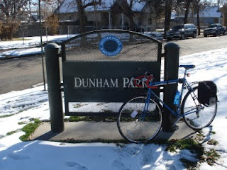
  • 6.54 miles - Past Dunham Park and then left onto 44th.


  • 6.77 miles - Right onto Steele. The first block or two of this stretch of Steele is pretty unwelcoming, but it gets friendlier.

    This is the beginning of an annoying two mile detour that is necessary to get around the damn puppy chow plant.

  • 6.90 miles - Between 43rd and 42nd, there are some train tracks that proceed east from here to Smith Road, which is where we ultimately want to go. I didn't investigate at the time, but if there is some cleared brush along the tracks that might support a mountain, or otherwise-off-roadable, bike then this could cut almost two miles off the route, as well as offer a brief, natural, rails-to-trails style respite from the otherwise very urban route.

    Warrants further attention.

  • 7.59 miles - Right onto E 35th Ave/Bruce Randolph. Down shift before turning. There's a steep little climb for one block. Continue past the City of Nairobi Park.

  • 7.97 miles - Left onto Jackson.

  • 8.72 miles - Jackson veers right and becomes Smith Road. Continue along Smith. Smith runs right next to the rail road tracks. I had the misfortune of riding down Smith once while a train was passing. The noise from the train was so loud that I couldn't hear anything, so I never knew a car was behind me until I could see it at my side as it passed me. Scary!

    Watch out for where the tracks cross the road here. They'll rattle your bones a little.

  • 10.71 miles - Just west of Quebec is the "Last Bus Stop In Town." It's a filthy little bus stop, the closest one to the mega big-box strip mall across the street. If you pass by here at the right time of day, you'll see six foot tall piles of Wall Mart and Home Depot shopping carts. It's the only solution for people who are dependent on the bus for transportation and who also need to do low-price/high-volume shopping.

    There's definitely an opportunity here for something. Be it some kind of a cart return service, or a shuttle service to and from the bus stop. Or maybe just a nicer bus stop. One that's not a bench surrounded by mud and litter. A canopy, some pavement, a trash can, and a cart return would do wonders, really.

  • 12.00 miles - Wall Mart. Effectively the end of the route.


  • 12.14 miles - End. The actual end of the route. Between Wall Mart and here, there are lots of prairie dogs to bark at you.

    The speed with which industrial/residential land turns into natural/feral land makes me realize and appreciate how much we're imposing our modern, urban lives upon the original, kinder and gentler, more natural inhabitants of the area. Those prairie dogs don't know what Wall Mart is, but they don't know what bikes are either.


To wrap up loose ends, I thought I'd return home at this point by jumping on the Sand Creek trail, which appeared to intersect Smith Road here. But I was unable to find it!

I think. Maybe I found it. But Smith Road was blocked off due to some kind of construction related in no doubt to the expansion of the nearby subdivision. So I veered into, and got lost in, the underbelly of Stapleton. I floundered around for quite a while until I stumbled upon Westerly Creek, which I was able to follow down to Montview and, ultimately, home.

I find it easy to protest Stapleton's cookie-cutter, "little boxes" style of development. But the streets were so nice. Wide, with sidewalks and bike lanes. And walking/biking trails all over the place.

They're doing some things right.

Sunday, November 15, 2009

bicycle parking


Yehuda taking advantage of available street parking. The first things I thought of when I saw were—
  1. That's totally legal. If you feed the meter, the space is apparently yours, whether or not you choose to fill it with a car.
  2. That's the concept behind Parking Day, an event that Denver participates in, but during which I have had to work for the last two years and so have never seen it in execution.


I'm afraid I discovered in myself a double standard the other day. While I support—and find humor in—Yehuda claiming equal access here, I caught myself cursing the owner of the Honda Ruckus that is still parked perpendicular to the curb alongside which I was trying to find parking. Its spacing from the corner made it such that it occupied an entire car's length. It could have been parked neatly between two cars, or on the sidewalk where every other 50cc in the neighborhood roosts.

I guess I'll cut him some slack.


It would be neat as hell to see a couple parallel parking spaces allocated for bike parking. That bike cage adequately addresses security in addition to the mere availability of space. I almost can't imagine a world in which you don't need to worry about securing your bicycle, but such places purportedly exist. For example, there are apparently no bike thieves in Copenhagen.

Friday, November 13, 2009

Pedestrian safety in Denver and elsewhere

Denver's rankings in T4A's "Dangerous by Design" report


Transportation for America released its Dangerous By Design report this week. The report assesses the danger of walking in major US metropolitan areas, and ranks the cities according to their Pedestrian Danger Index.

Fifty two metro areas were assessed. Denver ranked 23, with a PDI of 75.6, which makes it more dangerous than 55% of other areas. We're off the average of 77.4 by 1.8 points.

It is interesting to note that the ten most dangerous metro areas are all in the south, with the top four all being in Florida (Orlando/Kissimmee, Tampa/St. Petersburg/Clearwater, Miami/Fort Lauderdale/Pompano Beach, and Jackson). Having spent nearly all of my formative years in the south, I have to say this doesn't surprise me. It has been my experience that roads often narrow and lack sidewalks, and traffic flows through much too fast through residential and commercial areas alike.

Another table in the report shows the absolute number of pedestrian deaths, unadjusted—as the PDI is—for the number of people walking to work. Denver is tied for ninth most dangerous on this list with San Diego.

So absolute number of pedestrians killed by traffic in Denver is well above the norm, but because we have a proportionately large number of people walking to work, our PDI index is close to average.

New York City occupies a unique place on this list. It has among the highest number of actual deaths, and one of the lowest PDIs. Because they have by far the largest number of pedestrian commuters: 6% of all commuters, compared to an average among the other large metro area of 2.2%

Another figure reported is the average federal funds spent each year, per person, on biking/walking projects. Denver allocates $0.65 of its transportation budget, which gives it a ranking of 42/52 on this list. Bottom 10.

Interestingly, Tampa and Jacksonville, the 2nd and 4th most dangerous cities, are near the top of this list, shelling out $1.86 and $2.25 respectively. This is encouraging because it leads one to assume that the cities have recognized and are addressing the dangers detailed in this report.

Here are the figures for the other parts of Colorado.

Safety Rank within stateMetro AreaPedestrian Danger IndexTotal Ped. Fatalities (2007-2008)% of Traffic Deaths that were pedestriansAvg Yr Fed $ spent per person% workers walking to work2008 Population
1Denver-Aurora75.67920.4%$0.65 2.1%2,506,626
2Grand Junction38.237.0%$1.332.8%143,171
3Pueblo34.124.1%$1.081.9%156,737
4Greeley21.433.3%$0.412.9%249,775
5Boulder16.7410.5%$3.554.1%293,161
6Fort Collins-Loveland12.623.9%$1.732.7%292,825
7Colorado Springs6.733.4$0.693.7%617,714


Denver is obviously the most dangerous place to walk. Hopefully that will change as our Living Streets task force begins accomplishing tasks.

LAB's "Bicycle Friendly Communities" with Pedestrian Danger Index


The League of American Bicyclists maintains a list of "Bike Friendly Communities." as part of their Bicycle Friendly America program. Communities are evaluated on "the 5 Es" (Engineering, Education, Encouragement, Enforcement, and Evaluation & Planning) and a 28 page whopper of an application submitted by a representative of the community.

T4A's Pedestrian Danger Index cannot be applied directly to this list because the areas are defined differently. T4A defines "metro areas" such as Denver-Aurora, with a population of over 2 million. LAB "communities" tend to be defined by city boundaries, giving Denver a population just over 550,000.

But anyway, for curiosity's sake here are all cities in the top two tiers (Platinum, and gold) with, where available, the corresponding PDI.

City/CommunityRankPDI
Boulder, ColoradoPlatinum16.7
Davis, CaliforniaPlatinumNot available
Portland, Oregon
(PDI includes data from Vancouver and Beaverton)
Platinum36.4
Corvallis, OregonGold7.9
Eugene, Oregon
(PDI includes data from Springfield)
Gold31.3
Fort Collins, Colorado
(PDI includes data from Loveland)
Gold12.6
Jackson, WyomingGoldNot available
Madison, WisconsinGold7.8
Palo AltoGoldNot available
San Fransisco, California
(PDI includes data from Oakland and Freemont.)
Gold40.9
Seattle, Washington
(PDI includes data from Tacoma and Bellevue.)
Gold31.1
Stanford University, CaliforniaGoldNot available.
Tucson/East Pima, ArizonaGold72.8


Like I said, you can't really apply the PDI directly to this list, but it's interesting nonetheless.

That's all for now. I'm going to keep pouring through this report.

Thursday, November 12, 2009

One year of carfree living

I sold my car exactly one year ago. As of today, I have been car-free for one year.

During the past year, I've ridden in the dark, and during the day. In gorgeous weather, in the rain, and through the snow.

I've put my bike on the bus. I've cursed the bus on snowy days when I needed it and it simply didn't come.

I've fallen down.

I've puzzled over how best to carry stuff to work, and thrilled over new roads and alternate routes.

I've motivated coworkers to occasionally bike to work.

I've had a lot of fun.

And here starts one more year of one less car.

Tuesday, November 10, 2009

Bicycle Diaries


I'm off tomorrow, and I just got a hold of the new David Byrne book.

Score.

Ciclovia

"Ciclovia" is a Latin term referring to an event during which major roads are closed to automobile traffic so that pedestrians and non-motorized vehicles can flourish, thrive, and otherwise assume control of the streets.

I learned the word this morning from an LA Times article via the League of American Bicyclists. Apparently in Los Angeles, local advocacy group cicLAvia is gaining some support from the city council for organizing some ciclovias in downtown LA.

Now, we have our own ciclovias here in Denver, where we have "1st Sundays in the Park" at Cheesman Park five months out of the year, May through September. And that's cool. It's a lot more than other places get.

And our ciclovias being on Sundays, you can further flex your cyclist's rights by venturing two blocks north, down the Teenybopper Mallrat Route and down the 16th Street Mall should you feel like it!

Friday, November 6, 2009

Geohashing

Geohashing is a method for finding an effectively random location nearby and visiting it: a Spontaneous Adventure Generator. Every day, the algorithm generates a new set of coordinates for each 1°×1° latitude/longitude zone (known as a graticule) in the world. The coordinates can be anywhere -- in the forest, in a city, on a mountain, or even in the middle of a lake! Everyone in a given region gets the same set of coordinates relative to their graticule.


"Spontaneous Adventure Generator!" That sums up the appeal of this little game for me! It's the same thing I find appealing in planning out 60+ weekend rides. Trying new trails, plotting new routes. ADVENTURE!

Denver is geographically unfortunate because it is what is called a "split city," meaning that an intersection of graticules, those 1x1 longitude/latitude grids, falls almost directly in the middle of the city, and so we recognize four of them in our area: NE, SE, NW, SW.

Which means that our field of play grows from about 3,381 square miles (69 miles to a degree of latitude by approximately 49 miles to a degree of longitude at 45 degrees form the equator) to four times that at 13,524 square miles.

Which is a friggin lot.

The city and county of Denver is ~155 square miles.

So there's almost a 1/50 chance that it will fall within 10 miles of Denver.

Which all goes to say that in these parts, if a hashsite happens to be a reasonable distance from you, it's a shame not to go after it.

Like I did on Hallowe'en Eve.

Edit:

According to the tool at chemical-ecology.net the four-graticules sized grid is 138.09353334000397 miles by 107.31667373389479 miles long, or 14819.738662209928518 miles square. My original estimate was off by about a thousand miles. I'll now assert confidently, when asked, that our playing field is about 14,819.75 square miles.

Tuesday, November 3, 2009

Folders

LGRAB announces they have a new Jango Flik to test ride and review one day after admitting the allure of a folding bicycle!

They've previously reviewed Dahon folders, so I'm looking forward to a full write-up and comparison.

Monday, November 2, 2009

Don't want to use them, but don't want them to go away

As winter approaches, I begin avoiding bike lanes because they tend to fill up with snow, slush, leaves, and other debris.

But I don't want to contribute to the notion or to any statistics about bike infrastructure not being used.

How to I reconcile these two conflicting desires?

Bike around the world

So the other day, I rode home from the airport.

That accomplishment really captured my imagination.

I fantasize now about biking to the airport, packing up my bike somehow, jetting off to some distant place, unpacking my bike, and then continuing my ride.

Rental cars? Where we're going we don't need rental cars.


There are ways of accomplishing this.

S&S Couplers

One is a product from S and S Machines called Bicycle Torque Couplings (BTC), and which most of the rest of the world call "S&S couplers."

It enables you a trusted bike mechanic to essentially saw your frame in half and install these couplers. After that, you're able to disassemble your bicycle whenever you please in such a way that it fits into regular-sized luggage. That is, you can check it as you would any other bag and not have to pay an over-sized baggage fee.

Some frames, like Surly's Travelers Check, come pre-built using this technology. Other bikesworks offer to retrofit your favorite frame.

The appeal of this technology is obviously having a full-sized, travel-ready bike. Larger riders like myself might be skeptical of the integrity, comfort, and cargo capacity of the other obvious travel solution: a folding bike.

Folding bikes

Which brings us to folding bicycles. Like the Bike Friday variety.

They don't really appeal to me. And they don't really seem marketed as a solution to airline travel the way S&S Couplers are. Rather, they seem marketed to urban commuters who have short distances to travel and who are worried about space on the train for their bikes. Or space in their office cube for their bike.

I know Bike Friday's site has pictures of folks on tour with their foldies, but I'm just not really buying it.

But they do have their place.

And there are some groovy looking ideas on the drawing board.

Other powered

And then just for fun, there are motorized devices like Honda's the U3-X, and Yike Bike.

Being the elitist that I am, I commend them for their small footprint and then dismiss them for not being human powered.

And more importantly, you can't take those things on a tour of the San Diego countryside. They are commuter tools. Not traveling tools.

And in summary

I think the solution for me would be an S&S Coupler ready bike. And as far as those go, Surly's frame is pretty awesome.

I'm going to go pour over the specs and daydream.

Sunday, November 1, 2009

Bikes, burritos, and the Benevolent Bovine


Apparently locally-owned Chipotle is one of the sponsors for professional cycling team Garmin-Slipstream.

My interest in cycling is practical and not competitive, so there's really no reason for me to have known that before last night, when the Lady and I were on Chipotle's site looking for locations participating in Free Burrito Night.

(Free Burrito Night being every Halloween, from 6 PM - 10 PM. Show up dressed as a burrito—i.e., with a piece of tin foil somewhere on your person—and you get a free burrito. It's a family tradition here in the Unclefather household.)

In addition to team info, it includes a nifty little flash game called slipstream ride, wherein you play an easily toppled cyclist who is uprighted after each spill by a flying cow. The Benevolent Bovine.

Who I guess is later, at the end of the race, turned into burrito stuffing, to be enjoyed by the winners. Such a benevolent bovine!

Weird little game.

As far as bicycle related flash games go, I'll be sticking to my cyclomaniacs.

Ride safely! And should you stumble, may the Benevolent Bovine set you upright again!

Saturday, October 31, 2009

Friday, October 30, 2009

Back on the horse


I start to realize what a big part of my life biking is after I'm forced to take a break from it for some reason. I had a grin on my face and a "WHEEEEEEE!" on my lips that whole ride.


Unfortunately, my return ride coincided with Denver's first big snow of the season. Snowed for over 48 hours. During that time, I continued to commute and managed to fall only once.

It wasn't a hum-dinger of a fall by any means. I was going really slow on a side street. Just hit a hidden ice patch and fell on my left side, pushing my bike out from under me towards the curb. I was back on my feet, collecting my bike, and scooting onto the sidewalk within 3-5 seconds.

My left thigh has been sore since then. No bruising or anything. Nothing that's going to keep me off the road.

Glad to be back on the bike! Even when I fall off of it!

Friday, October 16, 2009

Google Trike

This morning, the google maps team invited us in this blog post to begin nominating off-street locations to be mapped out by the google trike.

You have till October 28th to submit a location at google.com/trike.

My first submission was not bicycle or Colorado related. I nominated the Ocean Beach Pier, up and down which I used to walk almost every day when I lived in San Diego.

Thursday, October 15, 2009

Route profile: 16th Street/Avenue

16th Street Mall and 16th Avenue are collectively known as the Teenybopper Mallrat Route.


One of Denver's stranger bike routes, notable for running along the spine of the city, but at the same time not really taking you anywhere.

Access to the mall is limited to one day out of the week; and 16th Avenue has a bike lane but is not part of the Grid, and eventually comes to an abrupt stop after a couple blocks.

The route starts at one end of the city at the northwest end of the 16th Street Mall, either at Union Station or at National Velvet.


Now, unless it's Sunday, you cannot ride on the 16th Street Mall. This is one of bikedenver.org's Big Four rules, right up there with No Riding On The Sidewalk. Bike here 85.7% of the time, and you'll get a ticket.

On Sunday though, you can cruise right down the middle of the road. It's an interesting 1.5 mile ride that's not without its own unique joys and frustrations.

At the southeast end of the mall, your route crosses Broadway and becomes E 16th Avenue.

16th Avenue is not listed on the City of Denver bike map as a "grid" route, or even as a local bike route, but simply as a "road with a bike lane."

So even the city recognizes that it's kind of special.

Personally, I have a tendency to forget about 16th Ave until I cross it coming from the north or the south, and I see a bike lane, and I think to myself, "Oh! An E/W bike lane! I need to go east … might as well use this convenient bit of infrastructure!"

So I turn onto 16th and cruise along, slowly progressing through the the stop signs that litter the route, until suddenly it dead ends at East High School.


Near the school, there is suddenly eleven or eight fleets worth of cars parked on the street, and there are always—regardless of the time day, morning or afternoon—handfuls of kids milling about outside.

Enough to make you want to point out to them that there's no such thing as education by proxy. Being at the school doesn't count. You gotta, you know, go inside and learn stuff.

Anyway, so suddenly you dead-end at the high school. You options for continuing are, to the south, Colfax Ave; and to the north, 17th Ave.

Neither of these streets are safe to bike on.

That leaves you the option of, to the north, continuing past 17th into and through City Park or, to the south, riding on the sidewalk on Colfax for one block before cutting back up to a safe side street.

Of these options, one is illegal (sidewalk-ridin') and one is inconvenient (the winding route through City Park takes you out of your way.)


So this route is interesting. It takes you from East High School to the far end of 16th Street Mall, and not really anywhere else.

But in doing so, you get really close to the real heart of the city.

Just off this route is City Park, Civic Center Park, the Central Library. Cheeseman Park is a short ride to the south. It runs parallel to all the wondrous crap on Colfax and it runs right through all the wondrous crap on the 16th Street Mall, including Skyline park. At the northwest end, you can get on the S. Platte River trail just north of the confluence with the Cherry Creek trail.

So from a wider perspective, I suppose it's quite a well connected hub.

But since all it literally does is connect a high school to a strip mall, I shall henceforth call this the Teenybopper Mallrat Route.

Wednesday, October 14, 2009

Kids in Crosswalks

October 7th was the ninth annual International Walk To School Day. Highly celebrated here in Denver. There are cute little "Kids in crosswalks!" signs posted around the neighborhood that are apparently going to be up for the duration of the month.

Walk To School Day is a concept that I find strange for some reason I can't quite put my finger on.

Rick Smith touched on the subject in the following Yehuda Moon.


And I guess he addresses what I find odd about making a big to-do about walking to school.

But I think that's only applicable when you're thinking about elementary and middle schools. This campaign could do some serious good work at high schools.

It'd be a challenge for sure, trying to convince a bunch of 16 year olds to leave their cars behind in favor of walking and bicycling. But I know I didn't consider biking to school a real or viable option when I was a kid, and it's less than 4.5 miles from my old house to my old high school.

That's nuthin.

I remember parking always being such an issue, too.

That's where this campaign should focus its attention. I used to walk and bike all the time when I was in elementary and middle school. After I got to high school though I didn't touch a bike for over five years.

Tuesday, October 13, 2009

Don't wanna share.

I was thinking about this "share the road" article as I was riding around town this afternoon. One premise of it is that "share the road" essentially evokes negative memories from Kindergarten of being forced to share your toys and your milk-n-cookies. Which is pleasant for no Kindergartner.

This time of year, bike lanes have a tendency to become useless and dangerous as they fill with leaves, ice and slush, and other road debris. Consequently, this is the time of year I tend to avoid roads with bike lanes. Instead, I find nice, wide roads. Multi-lane ones where I can take an entire lane without slowing traffic down.

I adhere as closely as I can to the principles of Vehicular Cycling.

In other words, I do a lot sharing the road with motorists.

And the problem with that is one of perception.

I may perceive myself as a vehicle with equal rights to the road, but that doesn't mean motorists don't perceive me as a slow moving object to avoid and to get around as soon as possible.

For example, this afternoon.

I was in the far right lane on a one-way, three-lane road. A white compact car was behind me; and next to it, one lane over, was a red sedan.

What happened next is when "share the road" means two different things to two different parties.

I have sometimes experienced that if I'm not assertive enough in my taking the lane—if I'm hanging out in the right-most third of the lane, or even smack dab in the middle of the lane instead of closer to the left-most third—then a motorist behind me might chose to interpret "share the road" as share the lane. And they'll drift over a little bit so that they're actually occupying two lanes as they attempt to pass me without getting all the way over.

There is some logic behind this tactic on a two lane road where changing lanes to pass me means driving fully on the wrong side of the road. Driving on the wrong side of the road is uncomfortable, even when conditions are clear.

But there is less logic—if in fact there is any—in sharing the lane on a wide, one-way, multi-lane road like we were on. There's no reason not to wait until it's clear, and then change lanes properly, like you would do to get around any slower moving car.

So instead of adhering to logic, the white compact attempts this share the lane tactic, accelerates and drifts towards the red sedan. Red sedan honks and the compact brakes and falls back in line.

One block down the road, I signal and leave the road, still next to the sedan, having obstructed traffic not one bit.

Being told to share the road may cause some people balk and insist that they keep all their cookies to themselves. But it is also problematic at times when those who would be willing to share don't know precisely what it means to, or how they ought to do it.

Share the road, folks. Not the lane.

Perhaps, as suggested in the article, we should abandon use of the slogan altogether and rely on simple "Watch for bicycles" signs.

Less connotation. Little more direct.

Sunday, October 11, 2009

Beausage


A portmanteau is a blending of two different words and their meanings. The word itself, in this context, was apparently invented by Lewis Carrol.

So some portmanteaus grate on my nerves. Labradoodle, Brangelina, and other designer words are manufactured and created by marketing departments in order to sell something flashy and fab.

And some portmanteaus are so accepted that you—or I at least—rarely notice them as being a jumble of two different things. Like brunch. Or spork, blog, and wikipedia. These words seem more natural, at least.

So Grant Peterson, of Rivendell Bicycle Works, apparently coined the portmanteau beausage in an article he wrote for the Rivendell Reader, the bike shop's newsletter. Rick Smith used the word in the 10/11/2009 episode of Yehuda Moon.

I think it's a pretty great word, with great potential to be used "in the wild."

It's a blend of "beauty" and "usage," and is used to describe a beauty that comes from or through use. Like dings and nicks on a trusty bicycle. Or a leather bicycle saddle once it has been broken in and has adopted the shape of its rider's bottom. Certain sets of kitchen knives acquire beausage after many years. Or—and this might be the perfect example—musical instruments. Like Trigger, Willie's guitar.


Where pronunciation is concerned, I'm going to go ahead and say that the American pronunciation ("BYOO-sij") and the French pronunciation ("bo-SAHG") are equally acceptable.

I'm looking forward to noticing and appreciating examples of beausage in the future.

bike google


Bike Pittsburgh spots the google trike and comments on plans to start mapping bike trails.

When I'm planning out a ride, I usually compare "Avoid Highways" driving directions to walking directions, and then overlay trailsdenver's trails map and my routes map.

Two suggested routes through two different maps, and then I'm able to plan out a third route through the city's bike infrastructure.

Sometimes, it is time consuming. Other times I throw caution to the wind and set out knowing only that I need to go generally southeast.

But I gotta admit, one-click bike routing will be handy.

Friday, October 9, 2009

City bike auction

I'm not going to be able to go to the city bike auction next week because I ... have a thing.

But they just posted the auction catalog, and man! There are like a hundred bikes they're auctioning off!

Pedicab vs. Taxicab

Video streaming from a NYC Fox News site, and found on LJ Bikepirates.


Which one of these seems like a disproportionate response to you? Throwing a cup of coffee at somebody's car? Or hitting somebody with your car?

The biggest danger of engaging a motorist is that—
  1. motorists have precious few avenues of communication, and
  2. a motorist's car is such an extension of his body that it may feel like hitting you with the car is not that different from hitting you with his fist.


In Tom Vanderbilt's Traffic, he says that there are several thing about driving itself that predisposes drivers to frustration and anger, the biggest of them being that it severely limits our abilities to communicate.

Humans are incredibly communicative creatures who rely heavily on nonverbal signals like facial expressions, body posturing, tone of voice and volume of voice. In a car, you are deprived of all of that. Instead, you are expected to use a car horn (often used too frequently) and a turn signal (often not used enough) to express yourself and convey depth and meaning.

Which is ridiculous when you think about it.

So this taxi driver obviously felt he could not adequately express his anger through any combination of sounding car horn and blinking turn signal. It's the torture of an artist, really. Having so much to share and not being able to articulate it satisfactorily.

But when an artist dramatically hurls a canvas painting across a room in frustration, people don't die like they do when a car hurls into people.

I myself had a "failure to communicate" moment the other day during my commute home.

A pickup truck and I were approaching a four-way stop from opposite directions. The truck didn't have its blinkers on, it was in the middle of the traffic lane, and its front tires were pointing straight ahead. So I logically assumed it was going straight.

Right up until it executed a right-hand turn directly across my path.

The truck had plenty of time to complete its turn. This wasn't any kind of a near miss, but I became frustrated at the lack of communication.

I raised my right hand in the air and starting doing that thing you do when you want to tell people to turn their lights on. Repeatedly closing my fist and then spreading my fingers wide. You know, that thing.

The truck then—in a surprise move—quickly pulled over to the side of the intersecting street and the driver hollered out his window, "What?"

Surprised to suddenly find myself in a conversation, I quickly blurted, "TURN SIGNAL!"

In answer to which he called back out, "Okay! Blobby flarggin blip bloop dada!"

Or something like that. I could only make out the "Okay!" before I was too far away to make out what he was saying.

He probably said something like, "Okay! And how about next you don't run the stop sign!"

Cause I did. I idahoed it.

Two sides to every story, right?

Like in the video above.

The pedicab driver ultimately chose to engage the taxicab by throwing his cup of coffee. And then he chose later to throw a friggin trash can at the driver.

I, on the other hand, did not pause or stop to throw anything at this pick-em-up truck. Because I knew I was a little bit wrong in this encounter, and that I would soundly lose an actual confrontation.

I, instead, was pedaling quickly away and discovering my "Donotgetintoafightwithatruck" mantra.

Point is folks, ultimately, go ahead and think twice before engaging the deaf, dumb, blind, raging bull-moose cars you share the road with everyday.

Thursday, October 8, 2009

Winter cometh

35 degrees and raining.

I actually love this time of year and this kind of commute. Because of the thrill of persevering despite the elements, and because of the smugness that comes from being a member of the exclusive All-Weather Cyclists Club.

I love the Man vs. Nature element of it. I enjoy that I now have to start watching the weather ahead of time so I can plan for both my morning and my evening commute. That I need to at times be ready for varying amounts of rain and snow, which sometimes means having to stop mid-commute to remove or add layers.

Being ill prepared or under-dressed is less dangerous now that my commute is 10 miles round-trip than it was back when it was about 20 miles, but it can still suck plenty bad.

This is also the time of year when you see fewer cyclists on the road, and the ones you do see are in it for the long run, just like you are. This time of year, when it's freezing and raining, if you see another cyclist you nod or wave, and they smile back. The comradeship is near the surface and it's easy to spot a kindred, nutty soul.

This is when cycling becomes an indoor sport for the fair-weather (possibly smarter) cyclists out there.

Sunday, October 4, 2009

Biking the 16th Street Mall: access to usually restricted areas

Today is Sunday.

In many ways, Sunday is kind of a tough day. Certain shops are closed, like Chick-Fil-A and 20th Street Cafe. Also, I live next to a huge Baptist church, and so there's no parking available next to my house on Sundays.

In fact on Sunday, you're kind of restricted in terms of stuff you can do. Wherein lies the appeal of doing something that can only be done on Sundays.

Such as taking advantage of "Big Four" Rule #4.

Six times out of seven, if you ride your bike on the 16th Street Mall, you'll get a citation. But on Sundays, it's fair game.

And that's really the only appeal: getting to do something you don't usually get to do.

Because it's not a terribly pleasant ride. Almost every intersection is a traffic light, and during my ride this afternoon—during which I rode from one end to the other and back again—I got stopped at nearly every light.

And it sucks to get stuck behind one of the buses.

And you must contend with the mental kung-fu that makes it such a great pedestrian mall: there's so much continuity between the sidewalk, the road, and the crosswalks, that it's possible to almost sail straight through an intersection without realizing it!

Other than that, though, it's neat scenery that you otherwise don't get to enjoy from atop a bicycle. Lots of public artwork to enjoy, people playing chess at the games tables in the median, shops that I always forget about between trips to the mall. You can detour down Skyline Park in the middle, or through Commons Park at the north end. On the other side of the north end is swanky Lower Highlands, where you can make a hard to beat one-two stop at Salvagetti and My Brothers Bar.

So I guess upon reflection that it's not that unpleasant a ride, as long as you know what you're getting into.

Yup!

16th Street Mall, I'll be seeing you again next Sunday!

Hazards of the separated lane: bikes go in the street!

Today's ride left me feeling like I should from time to time carry a broom and a dustpan with me on my commute.

There was so much broken glass at so many points along the way.

On roads where there were bike lanes, it was in the bike lane. On roads where there was no bake lane, it was in the furthermost third of the road where bikes tend to ride.

It was like there was a bottle smashing party last night!

It made me think about the approaching winter, and how when after it snows around here, the plows shove all the ice and snow and slush directly into the bike lane, rendering it useless in its inaccessibility.

Which is I guess what must happen to some extent now, with broken glass being the snow and regular traffic being the plows.

The regular flow of traffic probably contributes to all that crap being deposited in the way of bike traffic.

Which leads me to the ultimate conclusion that bike lanes just aren't the best thing for cyclists or for motorists.

Cyclists get a false sense of security from a piece of infrastructure that tends to act as a gutter on the side of the road, and motorists get the false—and dangerous—assumption that cyclists go on a special little section of the road, not on the "real" road, and so they don't have to watch out for them as much. And that they're not any more a part of traffic than rollerbladers or joggers.

I don't agree with John Forester about everything, but I do agree that bikes belong on the road, proper. And not on special bike lanes.


Incidentally, one of the guys at Salvagetti said that when he realizes he just rolled over some glass, he swings his foot out and lets his shoe rub on the tire for a few revolutions because "it's not the initial contact with the glass, it's the grinding it in that happens next."

I'm dubious of the actual effectiveness of this, but I keep doing it. Mostly because it gives you something to do. Otherwise, if you don't immediately dismount and check your tires for punctures, you just groan and swear and keep riding.

I'll tell you what, it's a feat of contortion to do that with fenders!

Friday, October 2, 2009

Gandhi's birthday

Sometimes, like some of you I'm sure, I am alerted to certain observances, celebrations, and holidays by the Google homepage.


For example, today is Gandhi's birthday.

Happy birthday, Gandhi!

You'd be 140 years old!

Here's a short excerpt from Jeff Mapes's Pedaling Revolution, in which the author is quoting one John Dowlin.
"I really felt the bicycle could be for the world's cities what the spinning wheel was for Gandhi," he said as we sat inside and warmed ourselves with coffee. Just as Gandhi saw India producing its own cloth as a way to free itself from British domination, the bicycle could free urban centers from an over-reliance on cars.

It's a cute analogy.

It's not too far off base to describe car culture in terms an oppressive, imperialist force.

And rebelling against British authority is kind of hard wired into our cultural identity, isn't it?

Thursday, October 1, 2009

Wednesday, September 30, 2009

You taken that Mtn Bike on any Mtns?


In Pedaling Revolution, Jeff Mapes commented very briefly on utility vehicles—both motorized and human-powered—being used to their specification:
"Just as most SUVs never went off the paved road, most mountain bikes sold probably never touched the dirt."


Cars and bikes both can be used to their exact specification. You can get a Land Rover or a Gary Fisher and go crashing through the wilderness. You can get a sports car or a cyclocross bike and race it.

A lot of people don't do that though. They don't use their vehicles to their exact specifications. They don't take their mountain bikes outside the city, and the only racing they do is from traffic light to traffic light.

Which is okay.

As long as you're on a bike. Not so much if you're in a car.

If you're consuming all the extra resources needed to fuel an over-sized sports car engine, or to fuel an over-sized SUV, but you're not doing anything with those vehicles but commuting to work or going to the grocery store, well then than that's kind of wasteful isn't it?

It doesn't require any extra resources to move a mountain bike or a racing bike through the same urban environment. Because, after all, your engine remains the same no matter what bike you're on. (Your engine is you!)

What I ultimately mean to say is that I got some bias! I got some bias, and I got some double standards!

I think it's okay to have a mountain bike that never touches dirt. I don't think it's okay to have an SUV that never leaves the road.

And I'm quite content in my bias here, folks!

Bike the airport, bike the world

A week ago, I had the opportunity to try biking to Denver's airport. Leading up to this ride, I scoured blogs, emails, and mailing lists for accounts of riding to DIA, but to no avail.

I know I read something last year about somebody commuting to DIA on BTWD. But now, I was unable to turn anything up.

And so now, I write! Denverites, if you are contemplating a ride to the airport, read on!


There was a needlessly complicated series of events that resulting in me needing to drop off a car at the airport and then find some other way to get home.

I elected to bike it up!

I had been itching to try this ride. Access to an airport has come to stand in my mind as a great measure of a city's bike-ability.

And Denver must have one of the least accessible airports in the nation.

Or maybe I'm just prejudiced by the fact that I lived in San Diego for so long, where you can literally walk to the airport from downtown.

Denver International Airport is on my bike map now. It was a 2 hour ride, but I proclaim it Bike-able.

Two portions of the ride warrant elaboration.

The first is Pena/Airport Boulevard, and the second is Copper Flats/Meadows MHC.

Pena/Airport Boulevard


Holy crap, this leg of the ride a white-knuckle Fright Fest.

First of all, Pena Blvd is a designated bike route.

You'll see a lot of the "DIA Bike Route" sign.


I don't know why it's reassuring, but it is. At least you know, I guess, that you're not doing anything illegal.

Because it does feel like you shouldn't be allowed to bike on Pena. Cars are whizzing by at 70+ MPH. You're basically riding your bike on the interstate.


Or, on an interstate highway with an extra wide shoulder designated as a bike lane.

The shoulder is nice, smooth, maintained as a bike path, and always at least one full car lane in width.

It feels adequately safe.

Until you start riding through shreds of rubber, and you realize that a poorly timed blow-out would send a passing car hurtling into you at Instant Death speeds.

So you throttle and choke your handlebars, and you coach yourself through breathing a lot.

And navigating exit/entrance ramps is challenging. You basically have to stop and dismount, and walk across the ramps. Because you can't really assess the intent of approaching cars while you are moving: Exiting? Not exiting? Blinker on by accident? Exiting without using blinker? Just can't tell at these speeds!

Riding Pena might sound scary.

That's because it is scary.

But it's doable. I'd do it again if I had to.

Copper Flats/Meadows MHC


About 12 miles from DIA is the intersection of East 13th Avenue and Sable Boulevard. Riding away from the airport, your route carries you south on Sable, and then west on 13th, at which point you encounter something a little surreal.

When you turn onto 13th, you quickly find yourself in the middle of Meadows MHC (Mobile Home Community). It's a cute-as-hell little trailer park.

Seriously, there are some neat looking mobile homes, the owners of which are obviously quite proud.

But then after only a few blocks, 13th suddenly dead ends at a chain link fence.

Just as you're about to omfg and pull on the brakes, you see a little slit in the fence, and you see a narrow strip of asphalt continue across a meadow.

So you continue through the fence, into the meadow, and suddenly you're in a crazy No Man's Land.

There's broken glass on the strip of a trail. There's a discouraged looking vagrant pushing a shopping cart across the meadow. Prairie dogs are dodging, ducking, dipping, diving, and dodging. And barking at everything that moves. A couple of bedraggled leathernecks in wife-beaters are drinking beer at 10:00 AM, looking at you with their eyes. Hard.

Then you go under I-225 and suddenly you're at another chain-link fence at Tollgate Creek.


So you continue through another gap in another fence, across this funny little foot bridge, and you emerge on the other side ...


In Copper Flats. A swanky, gated community with a clubhouse and a pool and parking and a flashy website.

And you can't help but assume that at night, the Copper Flats kids and the Meadows Trailer Park kids meet in the barren Prairie Dog meadow and have monkey knife fights in the light of the moon.

Monday, September 28, 2009

Worksman Cycles copes with economy

Wayne Sosin, president of Worksman Cycles, my favorite utility/industrial bike company, is mentioned in a New York Times article about small companies coping with the economy.

Sunday, September 27, 2009

Bikes and kites

This morning, Ladyfriend put the dog in the tricycle basket and I stuffed a kite in my pannier, and we rode down to City Park for a little kite flying!

Two cycles. Five wheels.


Me flying the kite.


Ladyfriend flying the kite.


Close up of the $5 "Iron Man" kite I got at the hardware store.


Just because you're tethered to a person doesn't mean you fly in the air. Sometimes it means you roll in the grass.


'Twas a lovely morning!