D2. The northernmost E/W route on the grid. It stretches from the Denver/Jefferson county at 43rd and Sheridan, by Lakeside Amusement Park and Berkeley Lake, across town to Wall Mart, just this side of Stapleton. And between the two endpoints is a nice little ride!
- 0.00 miles - West 43rd Avenue and Sheridan Boulevard. This initial stretch of road is pleasant because you start out right on Berkeley Park. I loved going to this park when I lived near here. It has a rec center with a pool, a fenced in dog park, a public library, a big lake with fishing and a walking trail around it. It was tempting to stop the ride before it even began and loiter about, enjoying the morning here.
- 0.07 miles - Double sharrows!
- 0.52 miles - DOUBLE EFFING SHARROWS. (At Tennyson St.) There are three generations of sharrows painted on this street. The most recent ones look bold and bright. The next oldest are clearly visible, and the oldest ones are very faded. But you can see nearly all of them clearly enough. There's one every couple of feet! It's impossible for a motorist on this street not to know that there may be bicycles about.
- 1.14 miles - Rocky Mountain Lake Park. Another park. With another lake. But this one has a big damn frog.
And how does this rinky-dink little park win the thousand dollar name of "Rocky Mountain Park?" Is it the big damn frog? Must be. - 2.60 miles - Turn right onto Navajo Street. The turn is labeled. If you're paying attention, you can't miss it.
- 2.92 miles - Turn left at West 43rd Avenue. This turn is not labeled. If you don't know to turn here, you'll miss out on the best part of ride, coming up ahead.
- 3.24 miles - 43rd Avenue dead ends at Inca Street. At the 43rd Ave Foot Bridge!
I wasn't positive this thing existed. I decided to do this ride in the first place because somebody arrived at this website by searching for "denver d-2 bicycle 43rd bridge." I felt bad for whoever that was because I, until now, I didn't have a lick of information about it.
So when you turn on to it, 43rd dead ends after only a few blocks at Inca Street. Beyond Inca are the train tracks. Before the tracks is a several stories tall foot bridge. I didn't think it was open at first because of the abandoned fire tower look it has, but when I went in for a closer look, I discovered that it's a solid, concrete over pass. There's a small stairwell in the middle that you have to carry your bike up (PORTAGE!) and then you have to carry it back down the other side again, obviously. And then there's a small patch of dirt between you and where 43rd continues.
Portaged my bike and got some mud on my tires. Awesome. - 3.45 miles - Left on Fox Street.
- 3.53 miles - Turn right onto West 44th Avenue, which will carry you right over I-25, and then curve north to parallel the freeway.
- 3.99 miles - Turn right onto East 45th Avenue. And welcome to Globeville! This is a neat little neighborhood. Globeville proper spreads out farther than this, but this is a cute little 3x8 blocks neighborhood confined by I-25 the to west, I-70 to the north, and the Platte River to the south and east. Watch out for the White Owl on your left. Apparently a groovy little dive bar. I'll have to go back for a few brewskies some time.
- 4.46 miles - Across Washington Street is BikeDonalds, which sits right on the South Platte trail, has ample bike parking and bicycle themed art on the walls inside. Either stop for a milkshake, or continue through the parking lot, onto the trail, and north one exit.
- 4.72 miles - Go under E 47th Ave (it's labeled), keep going for a heartbeat and then turn around and proceed up the ramp. Turn left onto 47th and continue towards the Colosseum/National Western Complex. 47th Street will go underneath I-70 and then dead-end at a stop sign. Turn left. Hard left. Onto Humboldt.
- 5.32 miles - Turn right onto East 47th Avenue.
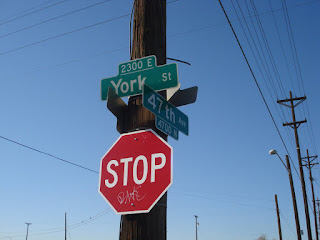
- 5.92 miles - Here's a funky little place where 47th starts to curve northwards, and then crosses York and you have to turn hard right, almost doubling back the way you came, and then continue across to remain on 47th. It's not tricky. It'll make sense when you see it. It's not a big deal.
- 6.24 miles - Right onto Clayton
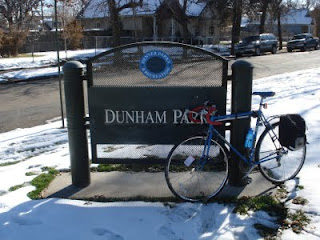
- 6.54 miles - Past Dunham Park and then left onto 44th.
- 6.77 miles - Right onto Steele. The first block or two of this stretch of Steele is pretty unwelcoming, but it gets friendlier.
This is the beginning of an annoying two mile detour that is necessary to get around the damn puppy chow plant. - 6.90 miles - Between 43rd and 42nd, there are some train tracks that proceed east from here to Smith Road, which is where we ultimately want to go. I didn't investigate at the time, but if there is some cleared brush along the tracks that might support a mountain, or otherwise-off-roadable, bike then this could cut almost two miles off the route, as well as offer a brief, natural, rails-to-trails style respite from the otherwise very urban route.
Warrants further attention. - 7.59 miles - Right onto E 35th Ave/Bruce Randolph. Down shift before turning. There's a steep little climb for one block. Continue past the City of Nairobi Park.
- 7.97 miles - Left onto Jackson.
- 8.72 miles - Jackson veers right and becomes Smith Road. Continue along Smith. Smith runs right next to the rail road tracks. I had the misfortune of riding down Smith once while a train was passing. The noise from the train was so loud that I couldn't hear anything, so I never knew a car was behind me until I could see it at my side as it passed me. Scary!
Watch out for where the tracks cross the road here. They'll rattle your bones a little. - 10.71 miles - Just west of Quebec is the "Last Bus Stop In Town." It's a filthy little bus stop, the closest one to the mega big-box strip mall across the street. If you pass by here at the right time of day, you'll see six foot tall piles of Wall Mart and Home Depot shopping carts. It's the only solution for people who are dependent on the bus for transportation and who also need to do low-price/high-volume shopping.
There's definitely an opportunity here for something. Be it some kind of a cart return service, or a shuttle service to and from the bus stop. Or maybe just a nicer bus stop. One that's not a bench surrounded by mud and litter. A canopy, some pavement, a trash can, and a cart return would do wonders, really. - 12.00 miles - Wall Mart. Effectively the end of the route.
- 12.14 miles - End. The actual end of the route. Between Wall Mart and here, there are lots of prairie dogs to bark at you.
The speed with which industrial/residential land turns into natural/feral land makes me realize and appreciate how much we're imposing our modern, urban lives upon the original, kinder and gentler, more natural inhabitants of the area. Those prairie dogs don't know what Wall Mart is, but they don't know what bikes are either.


To wrap up loose ends, I thought I'd return home at this point by jumping on the Sand Creek trail, which appeared to intersect Smith Road here. But I was unable to find it!
I think. Maybe I found it. But Smith Road was blocked off due to some kind of construction related in no doubt to the expansion of the nearby subdivision. So I veered into, and got lost in, the underbelly of Stapleton. I floundered around for quite a while until I stumbled upon Westerly Creek, which I was able to follow down to Montview and, ultimately, home.
I find it easy to protest Stapleton's cookie-cutter, "little boxes" style of development. But the streets were so nice. Wide, with sidewalks and bike lanes. And walking/biking trails all over the place.
They're doing some things right.


No comments:
Post a Comment